Hello friends!
As I noted in my last post, I started a new Torchbearer game a few weeks ago. I’ve subjected this particular group to a number of playtests of new adventures recently, all of which have ended in TPKs. They’ve been good sports, but they were ready to commit to something longer term (with the hopes of actually surviving a dungeon or two).
For my part, I wanted to get back to Torchbearer’s roots. One of the key ideas in my head when I first started working on the game was the idea of a map that would start with just a few locations and then grow over time as the group explored it and new details were added. That’s the core idea behind the Prepare Thyself chapter in the book.
I decided that we would start the game in the Middarmark, specifically in the Gottmark of the far north because it’s been unexplored territory in our games so far. I went to my Middarmark map and selected the boxed part of the map below. Specifically, I think it’s the little saddle between the mountain in the southwest portion of the map and the hills above it.
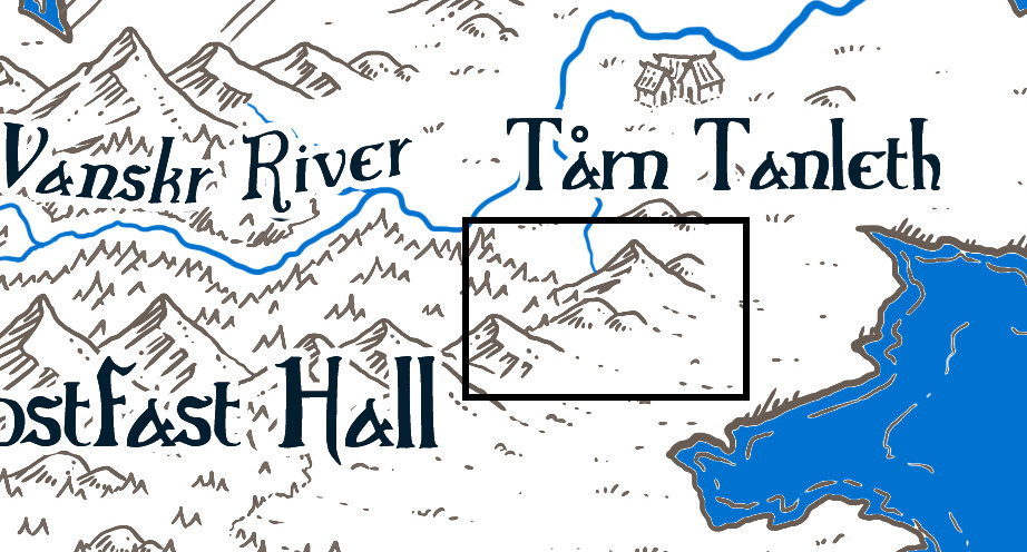
For me, the hardest part of making any map is where to start. I often find that picking an anchor geography point or points helps get me going. Part of what drew me to the section of the Middarmark map I chose is that big mountain at the top of the box. I chose that as my anchor point. I also know that I want to include Highwater (the port city from The Secret Vault of the Queen of Thieves). We’ll put it somewhere on the coast, though probably not on the initial map. That’s my second anchor point.
Water Is the Driving Force of All Nature
The other thing that really helps me figure out a map is water. Bodies of water make excellent boundaries, but they also connect people. Settlements tend to spring up along coasts and river systems, especially river systems that are navigable. The section of the map I chose is south of the Vanskr River, which runs east out of the Nidfjolls into the Skyet Sea. That river is a little too far north for my initial setting, so I’m going to add a new river and tributaries that flow south and east out of our little valley to the coast.
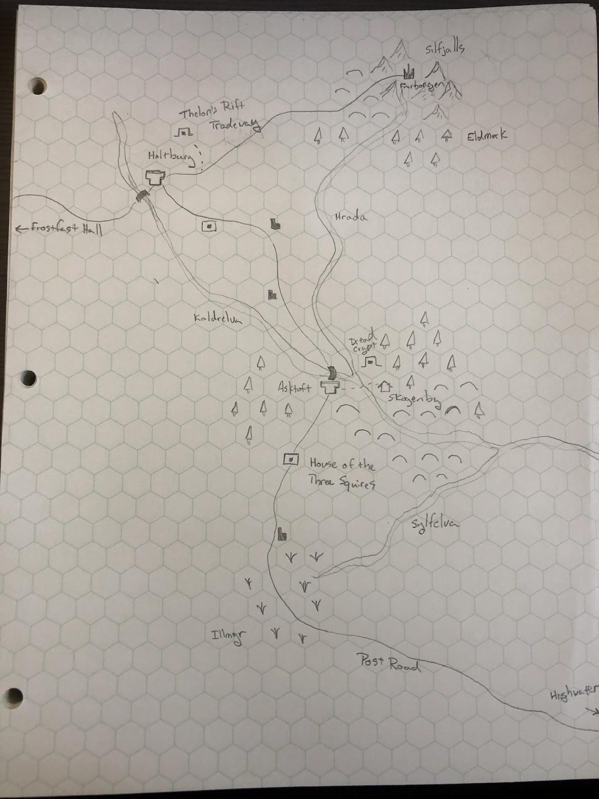
So that’s where I started: I penciled in some mountains in the northeast of my map and a river with tributaries.

With that done, I named the rivers. The primary river, flowing out of the mountains to the north, is the Hrada, a play on the Old Norse for ‘swift.’ The tributary that originates to the west is the Kaldrelva (Cold River). The southern tributary is the Sylfelva (Silver River). I’m not terribly concerned about linguistic fidelity, I just want the sound of it to feel right when spoken. By the same token, I decided to call the mountains the Silfjalls (Silver Mountains).
Names have a kind of magic. When you name something in a role-playing game, whether a character, a house or inn, a city, or a sword, you make it just a little more real, more substantial, to everyone else. A sword found in a tomb? Big deal. The Sword of Seven Shadows found in the tomb of Aras-Ekbar? That’s something special. Give things names!
At BWHQ, we like to keep foreign language dictionaries handy when we play for just this purpose. And I should note that when I run games in the Middarmark, I probably reference the names lists on pages 52-53 more than anything else in the book.
The Journey Itself Is Home
With the backbone of my map done, it was time to place some settlements. I needed a starting base for the PCs — not necessarily a hometown, but a place that doesn’t have any adventures attached to it (at least at the beginning) that the characters will be able to return to and spend their spoils.
For that purpose, I created Asktoft, a somewhat prosperous town that serves as the seat of a Gott ridder (a knight of the Gott tribe) named Gry. If you’ve run or played The Dread Crypt of Skogenby, you might recognize Lady Gry as the absentee lord of that benighted village. And, in fact, I decided that Skogenby is just to the east of Asktoft. There’s a natural ford of the Hrada right there.
I decided to put a wealthy crossroads town in the north. That’s Holtburg. And I knew that none of my players had actually played the Under the House of the Three Squires adventure from the core book, so I decided to put that in the south. It’s on the way to the port city of Highwater.

There are almost certainly more remote villages and steadings located on this map, but we’ll discover them later. And that’s an important point, actually. You don’t need a ton of detail to start. You just need enough to give your players a sense of place and maybe inspire some curiosity. My friends Adam and Sage nailed this concept in DungeonWorld with the game’s GM Principles: The very first one on the list is, “Draw maps, leave blanks.”
“Dungeon World exists mostly in the imaginations of the people playing it; maps help everyone stay on the same page. You won’t always be drawing them yourself, but any time there’s a new location described make sure it gets added to the map.“When you draw a map don’t try to make it complete. Leave room for the unknown. As you play you’ll get more ideas and the players will give you inspiration to work with. Let the maps expand and change.”
DungeonWorld, page 162
Your map doesn’t have to be perfect and it doesn’t have to be complete. Leave plenty of room for your map to grow and evolve. Discovering and defining what’s in those blank spaces through play is a ton of fun.
On that Path Lies Danger
Like rivers, roads and paths are important to defining a map. The Under the House of the Three Squires adventure says the titular House is situated on the Post Road. I decided that would be the backbone connecting the House to Asktoft, Holtburg and even Highwater.
I imagine Holtburg has become as wealthy as it has because it sits between two dwarven cities: Frostfast Hall in the west and another outpost in the Silfjalls in the east. I settled on Frarborgen as the name of that city. The Tradeway is the road that connects the two dwarven citadels. Holtburg sits on the crossroads of the Post Road and the Tradeway.
I think the Tradeway between Holtburg and Frarborgen runs mostly through foothills, so I added some just west of Frarborgen. They probably run most of the length of that route, but for the moment I just put in a hint of them.
The original section of the Middarmark map that I chose shows a thick section of the Ironwold forest blanketing the course of the Vanskr River. I wanted to include that, so I added a hint of forest south of Frarborgen. Skogenby is named for the spruce forest that borders it, so I added some trees north of it as well. I think the forest actually spans the distance between Frarborgen and Skogenby, but no need to fill it all in at this point.
I like the idea of a mist-cloaked marsh that could be home to witches and other spooky things, so I added the Illmyr in the south. It’s the wetlands that gives birth to the Sylfelva and the Post Road runs right through it.

There Are Dark Shadows on the Earth
According to Prepare Thyself, I still needed an elven settlement. I decided there’s a hidden elven settlement called Eldheim in the trackless forest south of Frarborgen. It’s hidden, so I’m not going to put it on the map just yet, but I decided that this part of the Ironwold is called the Eldmork.
South and east, at the terminus of the Post Road, is the bustling metropolis of Highwater. Somewhere on the map, I haven’t quite decided where yet, is the Gott temple-complex of Helglund. I also haven’t decided on a wizard’s tower yet. To begin, players could come from Svartårn if they wanted to hail from a wizard’s tower, even though it’s a long, long way to the southwest.
Perhaps most importantly, I needed to place some dungeons and ruins on the map. I want to give my players some rumors about what’s going on in the area and let them choose where to go, what to explore and which dungeons to tackle. I’ve already got the House of the Three Squires on the map. And since I have Skogenby, I needed to add the Dread Crypt. I put another dungeon called Thelon’s Rift outside Holtburg.
There are a few other unlabeled locations on the map between Asktoft and Holtburg — probably abandoned wayhouses (similar to the House of the Three Squires) that have become havens for bandits or worse, but I’ll decide for certain when they come into play.
The map is roughly 10 miles to a hex.
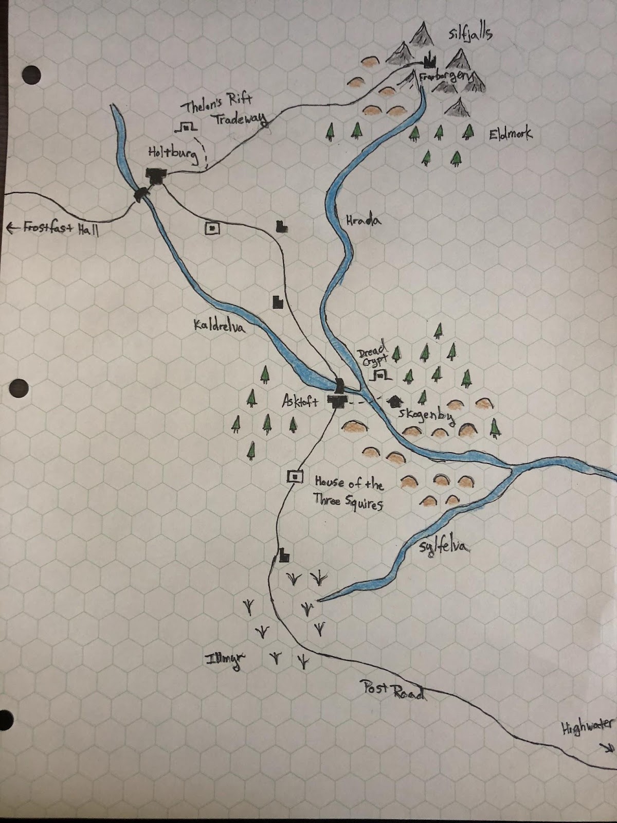
At that point I had all the starting elements of the map. I was satisfied, so I went over the pencil in ink.

And then I added just a little bit of color, which I like to do to help the map ‘pop.’
In all, this process took me an afternoon. I can’t wait to fill in the blanks on this map with my friends.
I want to hear your prep stories! What’s gotten you excited to play? What have you struggled with?